Showing posts with label 182Q. Show all posts

Tuesday, November 11, 2008

Flight to the elusive Big Bear, L35

Michelle and I have been trying to fly to Big Bear forever. Once I bought my Skylane, I felt more comfortable flying into high altitude airports. We tried flying down several times with N951CC, but didn't make it until today. Previous attempts were foiled by weather of course, fuel pumps inop at IYK, Michelle started feeling sick half way there, some others I don't remember, then I cancelled a trip with some friends to go there on Saturday due to an airmet for turbulence.

I want to fly into Big Bear for 2 reasons. The first reason is just to go there since it seems like a really neat place. The second reason is to tackle a high altitude airport. The airport is at 6,752 feet and has a single runway that is 5,850 feet long. Density altitudes can go above 10,000 feet in the summer, but shouldn't be too bad today. I want to go and visit my Uncle in Utah, but he lives in the high terrain so this will give me the confidence in my and the airplanes ability to land at high altitude airports. I also want to become more comfortable in higher terrain since I want to take a route through Colorado some year flying back to WI. This airport is a good practice airport and today I finally get my chance.

Today the winds were calm here, across the desert, and at Big Bear and forcasted to stay that way. There were very few clouds even visible in the sky but they were 20k or higher and hundreds of miles away. There were no airmets, sigmets, TFRs, or adverse conditions. There was only 1 notam and that was for the unmanned vehicle west of Victorville that has been there for the last year and a half. Long story short, it couldn't have been a nicer day. I had plenty of gas to get to Big Bear, but assuming their gas would be expensive way up there, I added some fuel (15 gallons) so I could make the round trip without more gas.

The air was cool and the flight was smooth as glass; I really love flying in the winter. As we passed over Hesparia I was looking at the map and the GPS and trying to compare to the mountain ridges I was seeing in front of me. I couldn't tell if I was supposed to fly around the near set of ridges or right over them. I decided to peek around them and found that I should have gone right over. Not a big deal, we just added 2 minutes to the flight time, but we did get a better view of the ski area.


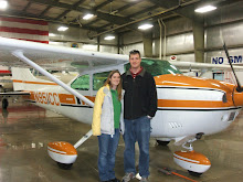
Mugshot

Lake Arrowhead

Ski runs

The winds were light out of the east and the traffic was using runway 8, which is right traffic. I flew east to the south of the airport and descended to the pattern altitude of 8,000 feet. It didn't take long to descend only 1,500 feet from cruising altitude to pattern altitude! I swung around and entered a 45 degree right downwind for runway 8 once conflicting traffic had me in sight and gave me the right away. The were further behind and slower so I was able to cut ahead of them with no problem.

45 to enter right downwind

I knew that I would need higher power settings for flying the pattern and landing, but I didn't know how much more. I usually use 2000 RPM in the pattern and 1500 RPM on the descent to land (with low power settings and the RPM at the high-speed stops, it's just like a fixed pitch prop and I use power to control the RPM). I found myself using more and more power to maintain level flight and 80 kts. I ended up around 2300 RPM. I extended the downwind a bit so I'd have more time to play with my descent on final. I set the RPM to 1800 and started down. I soon realized this was way more than I needed and I was very high on the approach. No problem, I put in full flaps and that put me on a perfect path to landing. The landing was just fine, but I did drift just a little.

A little high, but under control

As Michelle and I were walking towards the pilot lounge and restaurant, I noticed they had fuel at $3.50 per gallon!!!!! I just paid $5.19 at IYK expecting it to be more here, stupid me for adding gas before the flight. After we ate, I pulled the airplane over to the pumps and filled it to the brim with 35.9 more gallons, this saved me $60.67 over buying that gas at IYK.

It was pretty cool up at 6,750 feet, but I was comfortable in a sweatshirt. Regardless, the restaurant had indoor seating with big glass panel windows to see the ramp and the airplane traffic. I thought the food was very good, I had a bacon cheeseburger and a side salad. Michelle thought hers was only OK, she had strawberry crepes, but she thought they were too drenched in sauce. She was expecting them to be too drenched and wanted to order the apple cinnamon ones instead, but they were all out. I guess we'll have to go back for the apple cinnamon ones someday! They even gave us a coupon to come back.

On the flight back, we continued east instead of returning to the west and the high terrain quickly fell off. The approach to Big Bear is definitely easier from the east, but not too difficult from the west. It took us a few miles before I could establish communications with Riverside Radio to open my flight plan and LA Center for flight following. I lost contact with LA center before they handed me off and other traffic had to relay the hand-off. We were approved through Edwards restricted airspace above 6.000 feet on the way back and were home quickly.

Michelle had a very weird episode just as we were landing back at IYK. Just as I was turning to a 45 to enter downwind, she started screaming in pain. I didn't know if it was a pressurization thing and I should climb back up or if she needed to get down right away. I couldn't tell what was going on and she was just shaking her head so I kept on and flew a normal landing pattern. She was fine after we landed and she described it as if her tooth was about to explode. This weird though since I've heard of air pockets in teeth causing problems as you climb, but never as you land; weird. I logged 2.1 hours and finally our flight to Big Bear and back. Now I'm confident in our ability to take on the next high altitude airport, Panguitch, UT to visit my Uncle Errol. The Panguitch airport (U55) is almost exactly the same elevation and runway length as Big Bear so that should be no more difficult than today.

More pictures from this flight can be seen here.

Monday, September 8, 2008

Kevin and Shelvey Tajii's Wedding September 6th, 2008

This weekend Michelle and I flew up to San Jose for our friends Kevin and Shelvey's wedding. Kevin and Sarah Ford also flew up with us so we were able to planepool and save some money.

I needed to burn just a little gas so that we'd be under the maximum weight of the airplane so I flew for 15-20 minutes or so doing practice takeoffs and landings before we loaded the airplane for the trip. After burning the gas and checking what the Ford's brought for baggage, we were good to go. The trip was extremely smooth the whole way up there and I logged 1.9 hours on the tach including the practice takeoffs and landings.


I decided to fly into Reid-Hillview airport (add another to the map) since it would be cheaper and more convenient to fly into the San Jose International. After we got the rental car (which ended up being a huge extended cab truck since they were out of cars) we went and checked into the hotel early. Normally it would take 6+ hours to get up here not counting stopping for lunch, but were checked in to the hotel in less than 3.

After checking in, we headed up north to San Francisco to tour Alcatraz, but unfortunately the tours were sold out for the day, so we went to pier 39 instead. After getting some ice cream, we went and watched the sea lions. Sarah didn't have the best luck with her ice cream since a sea gull came down and snatched her cone right out of her hand. It dropped into the water and there was a frenzy with the birds. It scared the crap out of me since the sea gull just about hit me it came in so low, can't imagine Sarah since it DID hit her!

After pier 39, we went at drove past the famous Lombard street then headed back to the hotel. After a little swimming we were in bed for the night.

Saturday morning we went to tour the Winchester house. This is a crazy house that the widow of the second president of the Winchester gun company built since a psychic told her to keep building to appease the spirits of those killed by Winchester guns. Since she had to keep building the house at all times of day for decades, there were several unique features. A few interesting things were a staircase that went to all the way to a dead-end at the ceiling, a door out the second floor to nowhere, pillars mounted upside down, etc.


After the house it was time to get ready for the wedding. Unfortunately, we don't have many good pictures of the ceremony itself, but it was a good ceremony. I'll have to talk to Kevin when he comes back from their honeymoon about it. I thought they were going to do a traditional Buddhist wedding, but even though there were some unique parts, it seemed very traditional.


The wedding was fun and I didn't make a fool out of myself since I was the designated driver (only I was on the rental agreement).

Sunday we took off in the morning for the trip back. This trip was a little more interesting with much busier traffic coming out of the Bay and being swapped a lot by ATC while I was getting flight following updates. Then there was a jet that wasn't talking to anybody that was flying right at me. The controllers were finally able to reach him although he still seemed oblivious. While they were trying to figure out what he was doing, I climbed to 12,500 to get out of the way.

I was hoping to stop at Kernville for lunch, but there was a NOTAM that 100LL fuel was currently unavailable and I didn't have all the much fuel. I was worried if I descended all the way down there, I'd be too worried about our fuel level climbing back out to head home so we decided to skip Kernville and head home with 2.0 on the tach. This was Sarah's second trip that we weren't able to get lunch at Kernville, maybe we'll have to dedicate a trip some time...

Saturday, August 23, 2008

My first annual with N951CC

I just got through my first annual with N951CC and my first annual as an airplane owner. I think I was lucky compared to most new owners, but I still have some squawks to take care of. I was nervous of this annual because I know the engine is starting to develop some issues (leaking from the exhaust valve on #1), and because of financial concerns due to the post I'll publish tomorrow after our party tonight. All of the other cylinders passed inspection with ok compressions, but you can tell the engine is showing its age (2300 hours with 2000 normal Time Between Overhaul TBO). The borescope inspection of the #1 exhaust valve showed no burning so it was allowed to continue in service until the next inspection.

I spent last weekend (including Friday) out at the airport helping my mechanic with the mundane work of removing and replacing inspection panels, seats, and the interior floor carpeting. I also came in and tried to clean out the airplane inside the inspection panes. This was a pretty tough job, but I used 2 accordion type oil fillers from Wal-Mart and duct taped them to my shop vac so I was able to get into to some of the tough areas. I also had the plastic right elevator cap replaced with a new fiberglass one since it was crushed and bent. I was also able to help by removing the wheel pants, cleaning the grease from the rims, replacing a burnt out landing light, and removing the gear and strut fairings.

My mechanic found the ailerons were not hitting the stops simultaneously and had to adjust the rigging so that the right aileron hit the up stop as the left hit the bottom stop and vice versa. He also found the elevator cable tension to be too high and had to reduce it a little. All of these things were fairly minor and no major issues were found. I had squawked a bad gyro bearing earlier, but was unsure of which one it was. As we were troubleshooting a burnt out strobe light, it sounded like the turn-coordinator (which was spun up since it is electric and we had the battery turned on) was making the same sound so I sent for an overhaul exchange from Pacific Southwest Instruments. As it turns out, I did my post-maintenance flight today and the gyro noise is still there so it's a different instrument. There are only 2 other gyros in the airplane, the directional gyro (DG) and the attitude indicator (AI).

My mechanic washed the engine once he finished with the rest of the airplane and pulled it out of the hanger and I was able to wash the exterior this morning after my flight. I cleaned the airplane while the interior was removed and I cleaned the carpeting as I installed it. Next time I go out there, I'll clean the plastic interior, the panel, and the seats and it will be just like new.

Below are some pics I took during the annual.

Just going in starting to get disassembled.
Wings with the inspection plates removed.
Interior removed, inspection plates not removed yet.
Interior with the inspection plates removed.

Saturday, June 28, 2008

N951CC flight to Lancaster Fox Field (KWJF)

Michelle and I had planned on flying to Bakersfield yesterday for her to change her name at the social security office, but due to bad visibility from the nearby Clover fire in the Kennedy Meadows area (visibilities creating IMC in many locations and in some mountain passes), we had to drive there. We didn't have any plans for today, but the visibility was much better today and since we couldn't fly yesterday, we decided to fly to Big Bear for lunch since we've not yet made it all the way there. The weather was good, the TFRs along the route were avoidable (rocket launch to 27,000 ft and fires), and the winds and turbulence wasn't forcasted until 1pm.

It was a great day for flying, there was no wind at the airport and there was no turbulence on climbout; cruising at 8,500 ft was smooth. Unfortunatly the Edwards restricted airspace was active (it isn't usually on weekends) so we had to make a large diversion to fly around. Then, Michelle started to not feel so good.

It took us longer to get to the airport and airborne than expected since we hadn't actually planned on flying today. She hadn't eaten anything all day and flying to Big Bear would put lunch around 1pm and that means we'd be in the turbulence coming home. So again, we didn't make it to Big Bear and decided to divert and eat in Lancaster instead.

Not getting to Big Bear didn't bother me much, I really don't want to rush in there. They are located very high at almost 7,000 ft and the density altitude was already at 10,000 ft when I got my pre-flight. The approach into the area is over mountains that will produce lots of turbulence, so I'd rather delay the flight to another day instead of push an uncomfortable flight into terrible one. Michelle still is not sure how much she likes her new headset. She said it's comfortable with the exception that it pinches along her ears. Here's another mugshot of us, you can see Michelle's new headset as well.

Sunday, June 8, 2008

Flight to Mojave KMHV for lunch

Yesterday we planned on going to Big Bear Lake (L35) for lunch, we've never been there before, but it's a short flight to a mountain strip with an on airport restaurant. It's a resort area and supposed to be a very scenic flight. After checking the weather, getting a flight briefing, and filing a flight plan, we got out to Inyokern (KIYK) and it was strong and gusty winds that were not reported or forecasted. Knowing how screwed up the weather gets around here, we cancelled figuring it would just get worse and the forecast was already null and void. It turned out that it was only windy for 2 hours and then it calmed down, but we were already back home for the day; our plan was to go today instead.

Today I did the same thing, got the weather, did the briefing, and filed the flight plan. We got out to the airport and taxied over to the fuel pump since I needed more fuel for the trip. My luck again, the fuel pump was out of service. Determined not to give up, I called a few airports enroute and got a hold of a person at the Mojave airport. They said they did have fuel and their pump was up and working. Mojave is only a 30 minute flight from Inyokern and I had plenty of fuel to get there with reserve. Once we got there, we realized how late it was getting and that we wouldn't be able to eat until 1 or 2 at Big Bear, so we decided to just eat at Mojave and go to Big Bear another day.

The fuel was only $4.99 at Mojave so I made sure to top the tanks off. Last time I fueled at Inyokern, it was $5.19 and I was told this next batch coming in would be in the $5.60 range. I put in 63 gallons so the savings was almost $40! Well, it will be a few weeks before we get to Big Bear since we'll be in the Midwest for the next two weekends.

Here is our track for this flight.


And here is N951CC and Michelle in front of the Mojave air and space port tower and restaurant.


Saturday, May 31, 2008

N951CC OiL Change

As I was going through the reams of information about my new airplane, I realized I didn't know when it had it's last oil change. Cessna recommends that you change the oil every 50 hours, but the Cessna pilots association recommends 35 instead and my mechanic recommends 25 hours. I haven't decided on what I'll do yet, but I'll probably go to 25 hours since this is a high time engine and could use some extra TLC now. I know I've put a bunch of hours on it when I flew it back from WI so it was probably up for a change. Looking back into the logbooks, I found that the last change was in 2006 since it hadn't flown many hours since then. It was now 58 hours since the last oil change!

There is a local oil company that carries the aviation oil I use Aeroshell W100 so I bought a case and my mechanic and I changed the oil yesterday. This was the first time I was able to actually see my engine since I was sick during the pre-purchase inspection and the vacuum pump was replaced when I was working. Changing the oil is no different than a car. It's easier since I don't have to jack it up and crawl underneath, but more difficult since I have to remove the cowling and the filter is mounted upside down at a 45 degree angle, which means it spills all over when you remove it. The oil pan has a quick release valve on it so all we had to due was attach a hose and put it into a bucket and push the valve in. This part is a lot easier than pulling out a bolt and getting hot oil pouring everywhere.

My engine is most happy around 10 quarts even though it has a capacity of 12 quarts. I need a minimum of 8 quarts to fly. If I fill the oil to 12 quarts, the first 2 will get blown out the breather port and I'll be right back down to 10 quarts. So I filled it with 11 quarts since almost 1 quart will go into the filter.

While we were changing the oil, my mechanic was casually looking at everything to see what kind of shape it was in. Tug on this lever to see how loose the bearings are, see how tight that is, etc. He found that the airbox, which is the piece that connects the air filter to the carburetor had several sheared rivets. It was still held in place, but was loose. He took the air box off and we pulled out some of the sheared rivets and sure enough you could see they had been sheared for awhile. If they broke recently, the break would look like shiny metal, theses weren't. He also notice that one of the rivet tails was missing and most likely was already ingested into the engine. Good thing he caught this now before more go through the engine. All the pieces are still in good shape so he only has to re-rivet the box back together. Hopefully he'll be able to fix this quickly and we'll be flying soon.

Here are some pics of my engine.


Monday, May 26, 2008

Local flight on Memorial Day with Anthony

Today I went on a local flight with my friend Anthony. The winds were bad to the south, the clouds were low to the north, and it was raining and the clouds were obscuring the mountains to the west, so we decided to stay local. I guess we could have flown east to Vegas, but I was more in the mood for a shorter flight today. Next time we'll go get lunch somewhere.

We took off and flew south and circled Robber's Roost for awhile. Then we crossed over the El Paso mountains where I go Chukar hunting over to Garlock road. I let Anthony fly as we turned back west towards California City, then we headed north over Red Rock Canyon. We circled just a little more for traffic then landed runway 10 with 0.8 on the tach. We got to watch a glider come in on approach right over us and land on runway 20 while we held short on runway 10 after landing.

Here's another mugshot with Anthony. He had a blast and I feel bad that the weather wasn't better and we didn't get to go anywhere. I promised we'd go again.

Sunday, May 18, 2008

N951CC Flying to North Las Vegas KVGT

Michelle and I flew to North Las Vegas today for breakfast. It was a good flight and I wanted a quick flight there to get acquainted with the airspace. With the mountains immediately to the west and the McCarren class B airspace, I wasn't sure how much room there was for my descent to land. I flew through a saddle in the mountains that was further north than the last time I flew since this was in line with North Las Vegs, last time we flew into Henderson.

It turns out that the class B extends closer to the mountains than it seemed on the map so I had to descend close to the mountains just on the east side. This was incredibly scenic since we were flying right over their Red Rock hiking area. We were kind of pinched between the mountains, Nellis restricted airspace, and Vegas class B airspace that I was not cleared into. After a few passes north and south I lost enough altitude to fly under the class B shelf into KVGT. There are a lot of taxiways under maintenance and closed down so I asked ground control for taxi instructions, instead a "follow me" van was already right in front of me waiting. I followed him just a short ways to the transient parking.

There was supposed to be a 24 hour Bar and Grill across the street, but we didn't see it so we walked down the street to the Fiesta Casino and ate at their restaurant. Incredible breakfast specials and the food was good, but it was breakfast at a casino.

The flight back was pretty much the same but in reverse. I wanted to climb to be able to get over the mountains, but I had to stay low until I cleared the class B shelf. This put me right at the mountains so I had to circle to climb to get over them. I was hoping this trip would have been faster than it was since I figured I've got more performance in this 182 than I did in the 172 and I should be able to climb straight over the mountains. I didn't realize that I was going to be still limited, but by the airspace. Total round trip time was 2.6 hours, which is 2 hours and 36 minutes, so it still wasn't too bad.

The trip to Vegas was very smooth and was a great flight. The flight back was hot and bumpy, but we the bumps eventually went away as we cleared the mountains near Vegas. The air was cool at 10,500 feet so I never turned on the air conditioning. I did turn it on as we descended into Inyokern. The AC is nice because I waited until my downwind landing check to turn it off and from there, its only a few minutes until we were on the ground. I put the AC back on as soon as we were rolling out and it was way cooler than opening the windows. Too expensive of a toy to buy, but a heck of a nice one to come with the airplane!

North Las Vegas airport provides a free courtesy shuttle bus to the strip so it's a great airport to use when coming in to gamble on the strip. You do have to get your own taxi back, but that is the only service that isn't provided by the airport. Michelle has plans for next weekend so I'm smelling a poker trip with the guys...
Sorry no pictures, but we did find the camera now for next time. Here is a Google Earth look at the moutains flying into KVGT.


Friday, May 16, 2008

Vacuump pump replace, lock fixed, up and running!

My A&P finished replacing the failed vacuum pump and was able to fix the pilot door lock. He found all the pieces inside the door and had to lubricate it and it's working fine now. While he was working on it, I asked him to install some Rosen sun visors due to the intense sun out here.


I flew around the patch on May 2nd just to make sure everything was up and running smooth after the maintenance; it flew great.

May 3rd we drove down to San Diego for the Red Bull Air Races, see the next post for more info.

Michelle and I went on our favorite buger run on May 11th to Kernvill L05, but this time the service was terribly slow. We got there early before all the crowds, but they forgot our order and it ended up getting stuck behind a few large groups. It took an hour to get our food while we watched others come in, eat there food, and leave before we even got our food.


Here is a picture of the flight to Kernville in the Sierras. This is for road directions, but I pretty much have to follow the highway through the mountains. Once I clear the eastern mountains I fly down the middle of the valley and over the lake before turning up the narrowing valley towards the airport. The pattern is right traffic for runway 17 since the airport is right at the western base of the mountains.

I also have a picture of flying into Kernville a few years ago in another airplane, but the airport is the same. It's a lot of fun to fly into.


I got out to the airport for a few touch and gos today after taking part of the motorcycle training course. I already have my license, but the course is required for me to be able to ride the bike to work. I didn't fly for very long because I was getting hungry.

Michelle and I are planning on flying to Vegas for breakfast on Sunday. That will be a fun flight, I'm going to fly into North Las Vegas this time instead of Henderson since it is closer to down town. I doubt we'll go into town for breakfast, but this will be a nice flight to determine how long it takes to fly in and how to negotiate the terrain and airspace.

Wednesday, April 9, 2008

N951CC to CA Day 4 ** UPDATE **

Well like I said, sometimes they just put out AIRMETs for turbulence for an entire area. This was the case today. I checked the weather again about noon and there were 2 pilot reports of no turbulence along my route of flight. Also, the forcast for China Lake was updated and it was supposed to be calm winds. With this news I quickly asked the motel staff for a ride to the airport. The person who would give me a ride to the airport was a town meeting so I had to wait awhile for him, but I was airborne by 1:45.

The ride was pretty rough during the climb out and I leveled off at 8,500 ft since the were stronger head winds higher. There was continuous light chop at this altitude so I decided I would rather have a longer flight if it was smoother so I climbed up to 10,500 ft and it was smooth. I did lose about 12 knots of groundspeed, but it was a nice ride for the most part all the way into Inyokern.

Through the Palmdale - Mojave area, I was flying through smooth up and down drafts. I was getting + / - 1500 ft / min rates of climb / descent. It was pretty hard to keep a constant altitude. I called approach control to verify there was no conflicting traffic and to verify he was seeing the same altitude variations (so it wouldn't just be my pitot-static system). He confirmed and shortly after a Gulfstream jet flying into Palmdale reported updrafts as well. Anyways, they were smooth so it wasn't so bad. I had a tough time descending down into Inyokern because of the updrafts, but I circled for a while and eventually got down to pattern altitude.

The airplane is now tied down in it's shade hanger at Inyokern safe and sound. I'll have my mechanic take a look at the vacuum pump and door lock soon. Oh, the pilot door lock broke too. I think it might just be the retaining clip. I heard something fall inside the door and then the tumbler pulled out of the hole still on the key leaving a hole in the door. "Due to national security..." I have to have my door locked so I need to get this fixed ASAP.

I didn't take too many pictures of the trip. I guess I should have taken pictures of the airports I landed at, but I only got one of it tied down at IYK. Anyways, here is a slideshow of the pictures I did take.

http://picasaweb.google.com/jayson.brouchoud/N951CCToCA/photo#s5187462314526446306

UPDATE: Here is the GPS track of day 4 to CA

N951CC to CA Day 4

Well today is going to be a short post. I woke up bright and early and took a look out the window of my motel room. I could see the trees bending over in the wind. I called and got a briefing anyways and that confirmed the same story as yesterday afternoon. I'm not going anywhere today. After breakfast I walked over to the laundromat since I was out of clean clothes. Of course they are out of business. I talked to the motel staff and they said there was not other place in town to do laundry. So here I sit in yesterdays clothes typing about my trip to CA on my blog since I've got nothing else to do.

N951CC to CA Day 3

Since my original plan for Day 2 was to only get to Odessa, TX. I had planned my next leg to take me to Cochise, AZ (P33). Since I had made it to Winkler, I could now extend that leg a little. I wanted to extend this leg a little because otherwise I'd have to make a quick stop and a short flight near Inyokern. If I could extend this leg, I would avoid having that last stop. My plan now was to fly to Marana, AZ (KAVQ) just north of Tucson, AZ. I flew that flight at 10,500 ft and it was a nice smooth flight.

On the ground getting my next weather briefing for my last leg to Inyokern, I got the usual AIRMET for turbulence and strong surface winds. Palmdale, Mojave, Edwards, Big Bear, etc already had strong surface winds, but Inyokern and China Lake (KNID) did not. Inyokern does not get TAFs (Terminal Aerodrome Forecast), but China Lake sometimes does and they weren't forcasting strong winds for a few hours. Of course I took off with a alternate in mind (Victorville, CA (KVCV)). By this point, you're probably wondering why I keep taking off into turbulence and strong winds. I'll talk about that at the end of this post.

Just like yesterday, even though I just landed in smooth air, taking off now, I was flying in continuously turbulent air. I finally got to smooth air at 9,500 ft and it stayed smooth with only occasional bumps at 10,500 ft. I was nervous about the surface winds so I called up flight watch to get an update on Victorville. You guessed it, they now had horrendous winds. So I started asking for weather closer and closer to where I was to see how far I could get before I had to land. The next two airports I was supposed fly over were the last two with good winds so I started checking them out. The options were Gila Bend, AZ (E63) or Blythe, CA (KBLH). From the map, the yellow blobs for cities looked about the same size, but Gila Bend was much closer to the city than Blythe. This means there would be a much greater chance of getting a ride into town for the night.

As I was descending into Gila Bend, I noticed that my attitude indicator was indicating a very steep dive. I know I wasn't diving because I could look out and see where I was going. My altimeter and vertical speed indicators were also normal. This was my first instrument failure of my flying career. I've had a variety of issues before including engine problems, but this was my first instrument failure. Pretty soon it was saying I was climbing sky-high in a steep left turn. I wanted to just cover it up because it was distracting, but I didn't have anything handy. I just ignored it while I came into land.

As it turns out Gila Bend is a hole in the wall tiny place. There was nothing at the airport besides an abandoned building where an office used to be. I called the local motel that was supposed to offer transportation to and form the airport, but she said she was the only one working and could not come give me a ride. She gave me a number to the other motel in town, but I got the same response. Just about then, I saw some guys pulling 2 airplanes out of a trailer. I went over and talked to them. They had 2 jet powered airplanes roughly based on Jim Bede's BD-5 micro (http://en.wikipedia.org/wiki/Image:Bd5j.jpg). I was lucky they were there because they had planned on being at the Air Force auxiliary airfield to the south (KGBN), but apparently they crashed a plane on the runway shutting the airport down. That is why these guys were up here now. One of the gentlemen was nice enough to give me a ride into town. He mentioned he was a contractor for the military and that he comes to China Lake to work with the F-18 folks. From the website on the business card, it seems like they use the airplanes as radar targets (http://www.smart-1.us/). The guy's name was Robert Bishop here is a video that was on his website that talks about his work with the jet in the James Bond movie Octopussy.

So it was only noon and I was already stuck for the day. I decided to wander around the city, which only took me an hour since its so small. Most of the shops were closed and have very limited hours and working days. Most businesses aren't open here on Sunday through Tuesdays. At least this motel has internet and with nothing else to do, I went to take a look at the FARs (Federal Aviation Regulations) to confirm that the attitude indicator is not required for VFR flight and that I would still be able to make the flight home. FAR 91.205 lists what is required and does not include an attitude indicator. This makes sense because it is just an artificial horizon. This is very important if you fly in the clouds, but since I won't be and I can just look outside at the horizon, I don't need it for my flight.

So why do I keep taking off into turbulence you ask??? Well I now live in Ridgecrest so my airplane is based out of Inyokern (KIYK). This is in the middle of the Mojave desert at the Eastern Base of the Sierra Nevada's just south of Mt. Whitney. Every day I go flying I have to deal with strong winds and turbulence. I remember the days there WASN'T an AIRMET for turbulence instead of when there was one. The winds coming over the mountains create "mountain wave" effects and create a lot of turbulence and the thermals from the desert create a lot of turbulence. If I didn't fly every time they posted an AIRMET for turbulence and wind, I would sell my airplane. The weather usually is bad, but not unflyable. You just have to be careful and have an alternate in case things get bad. And trust me things do get bad, just not every time they forecast it. So that is why I now fall under the mindset of try and see, if it's bad land otherwise its just another AIRMET for flatlanders.

UPDATE: Here is the GPS track of day 3 to CA

N951CC to CA Day 2

For day 2, I had planned at stopping at Odessa, TX (KODO) for my next stop, but after looking at the map closer, I'd be descending through class C airspace, which isn't that big of a deal, but it would be easier if I just went a little further and land at Winkler, TX (KINK). As I was getting closer, I was checking the weather at the airports and Winkler started getting very strong winds and Odessa was still in good conditions so I decided to land at Odessa anyways. It was a short stop there and I picked up the weather briefing for my next leg. There was now an AIRMET (it warns pilots of bad weather) for moderate to severe turbulence and strong winds along the route. The forecast winds at my destination were not too bad and I had just flown in with no turbulence so I figured I'd give it a shot. If it gets bad I can always turn around and land at the nearest airport.

Well of course I had turbulence on my entire climb out. I called up flight service to get an update on my destination forecast and of course that was now also bad. Winkler airport was just in front of me and the winds weren't too terribly bad at this point so I landed there for the night.

When I went to tie-down, there were only thin chains there. I'm used to regular chains with hooks on them. I asked the man in the FBO if I was supposed to tie the chains like a rope or what I was supposed to do. After harassment for quite awhile about being unprepared and not knowing the hardware that is being used at the airports, he showed me how to tie a knot with a chain. This day hadn't gone as planned so why should I figure it'd get better now? He tied it really quickly and went back into the building saying I did one, you have to figure out the rest. I must have been there for 20 minutes trying to figure out his knot. I managed to do one on the other wing tie-down, but didn't know how I did it. Eventually he drove back out and showed me again and I think I learned it. He gave me a ride into town to a motel there. At least I was safe on the ground with a room for the night.

UPDATE: Here is the GPS track of day 2 to CA

N951CC to CA Day 1

Well I'm on day 4 of my flight from Manitowoc, WI (KMTW) to Inyokern, CA (KIYK) and I'm stuck again due to weather so I might as well post about my trip this far.

Originally I had planned on leaving Monday morning (4/7/08), but the weather in WI was threatening so I had thought about leaving Sunday afternoon. My family was having a get together for a late Easter since the family wasn't together on the actual holiday. My parents had other plans that night so I'd be able to get away and start flying back to CA. The forecast became worse so I decided to take-off Sunday morning. I felt bad because I wasn't able to visit my brothers, but if I didn't get out I'd be stuck in bad weather.

Since the storm that was rolling in was also coming through the middle of the country, I flew straight south instead of south-west so that I would have an extra day of good weather in case I needed it. I had planned on flying 3 flights that day each being about 3 hours. My first stop was supposed to be in Farmington, MO (KFAM), but there was a NOTAM (notice to airmen) that the field didn't have fuel, so instead I landed nearby at Fredricktown, MO (H88). It was a little field, but a gentlemen met me at the fuel pump and gave me a hand. The fuel there was only $3.95 (cheap compared to the $5.22 I paid at De Kalb, Il (KDKB)). I was able to borrow the airports courtesy car and drive into town for lunch. After lunch I was back on my way and my next stop was in Paris, TX (KPRX). Since I was running well behind schedule, I decided not to fly the third leg and got a taxi into town.

UPDATE: I decided to upgrade Google Earth to allow GPS tracks, here was my flight for day 1 to CA.

Saturday, January 19, 2008

N951CC

Here are a few pics of my new airplane.


Michelle and me in front of our new airplane. It's a 1979 Cessna 182Q Skylane with GPS, digital nav/comms, and air conditioning.


First time flying my new airplane (other than the test flight).