Today I did the same thing, got the weather, did the briefing, and filed the flight plan. We got out to the airport and taxied over to the fuel pump since I needed more fuel for the trip. My luck again, the fuel pump was out of service. Determined not to give up, I called a few airports enroute and got a hold of a person at the Mojave airport. They said they did have fuel and their pump was up and working. Mojave is only a 30 minute flight from Inyokern and I had plenty of fuel to get there with reserve. Once we got there, we realized how late it was getting and that we wouldn't be able to eat until 1 or 2 at Big Bear, so we decided to just eat at Mojave and go to Big Bear another day.
The fuel was only $4.99 at Mojave so I made sure to top the tanks off. Last time I fueled at Inyokern, it was $5.19 and I was told this next batch coming in would be in the $5.60 range. I put in 63 gallons so the savings was almost $40! Well, it will be a few weeks before we get to Big Bear since we'll be in the Midwest for the next two weekends.
Here is our track for this flight.

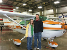
And here is N951CC and Michelle in front of the Mojave air and space port tower and restaurant.


test
ReplyDeleteJRB--
ReplyDeleteThanks for visiting/commenting on my blog (42andflying). Your blog is pretty neat, too.
To answer your question on the speed color tracks in my Google Earth GPS tracks...it's easy to do. When you go to www.gpsvisualizer.com and hit this page: http://www.gpsvisualizer.com/map_input?form=googleearth
Under "track options" I have the altitude "extruded", and then click on "show advanced options" for that section.
There, you'll want to choose units (nautical, US, metric...I use nautical), colorize by speed, and I put in 10 under "legend steps". This gives you a greater speed range, which I need to see when doing landings.
Good luck, and thanks!
Greg Perry
Huntington, WV
Thanks for the tips on GPSVisualizer. I used it today to track I flight I took and it turned out perfectly.
ReplyDelete