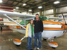
N951CC, out 1979 Cessna Skylane flew the family from Inyokern up to Lone Pine, CA for a short flight and lunch for Valentine's day. The weather was great and the air was mostly smooth. You could see reflections of mountains and clouds in the water that has filled the dry lakes. Due to the hot China Lake restricted airspace, I had to hug the Sierras for part of the flight. There is no transportation that I know of, but it is a short 1/2 mile walk from the airport to town. It was a great day to go for a walk. Lunch was OK, but the scenery was more worth the flight than lunch was.
Tuesday, February 23, 2010
Monday, February 22, 2010
N951CC flies to Ontario, CA
Now that Katie is starting to stand and climb all over everything, we wanted to go and look for a mini chair for her. We also picked up a bunch of diapers, a toy chest, and a bunch of other stuff. We had taken the bigger stroller with us for all the walking we did so we had a heck of a time fitting it all into the airplane on the way back. We made it fit and the flight was great.
I had requested and been approved by approach control to circle north of the airport to descend after flying through Cajon pass. The tower however wanted me to fly direct to the runway. I'm not sure why I came back saying I think I could make it, but the controller said I had "miles" when it was right in front of me and I was 3000 AGL (2000 above the pattern altitude). Ontario is a class C airport, which means it's a busy airport with airliners, but not quite Chicago or Los Angeles (class B). I try to cooperate as much as possible in order to not disrupt the flow of other traffic. In this case, I should have said unable and re-requested to circle. I had to fly an extended forward slip to descend in time and I used most of the 2 mile long runway to touchdown.
I had requested and been approved by approach control to circle north of the airport to descend after flying through Cajon pass. The tower however wanted me to fly direct to the runway. I'm not sure why I came back saying I think I could make it, but the controller said I had "miles" when it was right in front of me and I was 3000 AGL (2000 above the pattern altitude). Ontario is a class C airport, which means it's a busy airport with airliners, but not quite Chicago or Los Angeles (class B). I try to cooperate as much as possible in order to not disrupt the flow of other traffic. In this case, I should have said unable and re-requested to circle. I had to fly an extended forward slip to descend in time and I used most of the 2 mile long runway to touchdown.
Katie showing off her oxygen mask
Last year I bought an oxygen system at the EAA Airventure. The vendor gave me a free children's mask when I told him we had a baby. Now that we own a Cessna skylane, we are able to fly high enough to require supplemental oxygen. We are planning on flying from CA to WI this summer to visit family and to be part of the Cessnas 2 Oshkosh formation flight into the 2010 EAA Airventure.
In 2006 we flew through WA to fly north around the Rockies. In 2008, I flew through TX south around the Rockies (and weather). This year we plan on flying through the Rockies in Colorado and we will be flying high. Michelle and I have tested the O2 flying to Phoenix when we cruised at 17,500 feet enroute.
I've been gradually trying to get Katie used to the mask so that she wouldn't have a problem wearing it this summer. Up till now she freaked out every time I give it to her. This time she did great. She held it up to her face on her own and wore it for quite awhile without complaints.
Friday, February 12, 2010
N951CC flies to Santa Barbara
The family flew to Santa Barbara to visit with Lisa for lunch and to hang out on State st. This was the first time I landed at a class C airport. Seems weird that I haven't flown into one earlier, but I just haven't.
I heard a lot of reports of steep ramp fees, but those were waived with just 7 gallons of gas. Their rate was a dollar more than my home field so I really only paid $7 for ramp fees. I'd rather not pay anything, but this wasn't the end of the world. I certainly won't avoid Santa Barbara if that is the most suitable airport.
The flight there and back was nice and smooth, but we had to rush out in order to beat the sun. We won, but only by 30 minutes. Hopefully we'll have more time to spend there next time.
Michelle did some camera work to get some new points of view while flying. Here's the video.
Sunday, February 7, 2010
Katie is now standing on her own
Katie started standing on her own this past Friday (2/5/10). Before then she would stand for maybe a second, but would sit down right away. Now she stands for quite a bit at a time. She walks if she's holding a hand so now we just have to convince her to take her first real steps.
Monday, February 1, 2010
SPOT messenger and flight plans
This was a post on the Cessna Pilots Association forums that I thought was worth paraphrasing here just in case any pilots read my blog.
"BUT??? Did the pilot have a FLIGHT PLAN??? Isn't that the standard statement whenever there's a (non-News media) accident or incident..."
This comment spawned a question whether flight following or a flight plan was better.
There were a lot of comments saying flight plans were a waste of time unless you would be flying in areas where you are out of communication with ATC. Some people also brought up the SPOT messenger from http://www.findmespot.com/en/.
Here are my responses to these posts that I thought were worth repeating.
I'm really surprised and I guess disappointed by the number of people who say they don't file flight plans? You have to get a brief (if nothing else to check TFRs and NOTAMS) so why not just file a flight plan at the same time. You need to make them work for you so you don't have to put every twist and turn in and if you know it'll take you 30 minutes to close after landing then just add it to your time enroute. It's better than not having anybody come after you.
BTW, it doesn't matter which one is better, what is stopping you from doing both? I file a flight plan when getting my brief, turn on my SPOT and clip my "close flight plan keychain" onto my airplane key during pre-flight, open my flight plan as soon as I leave the vicinity of the airport, then call up approach for flight following. When I'm securing the airplane and take the keys out of the ignition, I'm immediately reminded to close my flight plan by the keychain.
My issue with SPOT is if you were disabled during the wreck or if it launched out of the airplane during the wreck, then you wouldn't be able to hit the 911 button. In my case I'd be relying on people to realize I'm missing and then remember I told them how to track me down using my SPOT track.

--------------------------------------------------------------
I'm glad I read this message because it got me thinking after I wrote that last post... I was wondering if I can somehow connect my SPOT with the flight plan so that search and rescue would have access to my last known GPS location. I called SPOT and flight service to see what I could do.
First I called SPOT, my questions were related to if no 911 message was sent and the FAA or search and rescue called asking for the info, would they give it to them. The answer was NO unless they were one of my emergency contacts! I'm assuming that is unless you hit the 911 where they contact the emergency services. I asked if I could put "FAA" or "Emergency Services" as an emergency contact and he said yes. My primary emergency contact for my SPOT is now "Search and rescue and emergency services". I guess I do like the privacy considerations, but it seems stupid to let search and rescue have to search when they could be told where I am and to expedite the rescue.
I also called flight service and talked about the best way to get this information onto a flight plan. For VFR they said it was easy since the remarks field is free form type. He can put "Pilot has SPOT messenger on board" or "Contact family for last known GPS location". He said they only had 12 characters for IFR flight plans. I know some mountain search and rescue folks and they all know what the SPOT messenger is so I figure I can put "SPOT MSNGER" for 11 characters on the IFR flight plan and be good enough. I will be highly disappointed if they were to search for me and not google "SPOT MSNGER" if they didn't know what it was. BTW, the first hit on google for "SPOT MSNGER" is the company's website. I think this gives you the best of all worlds and is what I will be doing from now on.
Jayson
Subscribe to:
Posts (Atom)